Preparations are underway to launch the Geographic Information System (GIS) for Monitoring and Evaluation of the development of regions and territorial communities.
This innovative system provides authorities with up-to-date data for making management decisions on the recovery and development of communities and regions, as well as monitoring and evaluating the implementation of these decisions. The GIS operation procedure was approved by the Resolution of the Cabinet of Ministers of Ukraine on 23 May 2023.
“The geographic information system allows us to monitor the compliance of management decisions on reconstruction with the national strategy, local programs and plans, and European standards and practices. Thus, GIS will become a key digital tool for regional development,” said Oleksandra Azarkhina, Deputy Minister for Restoration.
The European Union Anti-Corruption Initiative (EUACI) was one of the first partners to support the Ministry’s initiative. As part of the support, a technical concept of the system was developed, which defines the basic principles and functionality of the system, as well as its role in the digital recovery ecosystem.
“GIS is not only a tool for decision making for the high-quality and integrity reconstruction of Ukraine’s regions, but also an important tool for attracting investments, enhancing transparency and increasing the level of trust in local and national authorities. We are convinced that the adoption of the Cabinet of Ministers’ resolution is an important step for its further implementation. The EU Anti-Corruption Initiative intends to further support the implementation of the system as one of the priority digital tool for Ukraine’s recovery,” explained the EUACI Head Allan Pagh Kristensen.
GIS provides data analysis and visualization in the form of multi-layered maps. In particular, interactive maps allow to see the location of objects damaged or destroyed as a result of armed aggression, the level of access of communities to educational or medical services, the dynamics of population change in individual communities and regions, etc.
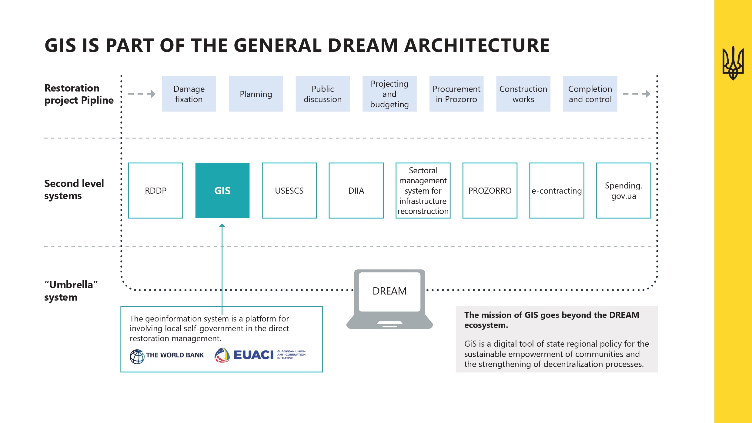
The GIS is an integral part of the digital ecosystem for recovery management DREAM, which provides monitoring, management and control of recovery projects at all stages.
The development of the GIS has already started. The system is planned to be put into trial operation (MVP) by the end of 2023. It is expected that the GIS will be harmonized with European practices, allowing Ukraine to access the best EU funding policies and programs.